RTMA and URMA#
This tutorial shows you how to download the Real-Time Mesoscale Analysis (RTMA) and Un-Restricted Mesoscale Analysis (URMA) products with the Herbie Python package.
For RTMA, use
model='rtma'For RTMA Rapid Update, use
model='rtma_ru'For RTMA Alaska, use
model='rtma_ak'For URMA, use
model='urma'For URMA Alaska, use
model='urma_ak'
[ ]:
from herbie import Herbie
from herbie.toolbox import EasyMap, pc

from herbie import paint

import matplotlib.pyplot as plt
[9]:
H = Herbie(
    "2024-01-01 06:00",
    model="rtma",
    product="anl",
)
✅ Found ┊ model=rtma ┊ product=anl ┊ 2024-Jan-01 06:00 UTC F00 ┊ GRIB2 @ aws ┊ IDX @ aws
[10]:
# Show available products
H.PRODUCTS
[10]:
{'anl': 'Analysis',
 'err': 'Analysis Forecast Error',
 'ges': 'Forecasts',
 'pcp': 'Precipitation Field'}
[11]:
H.SOURCES
[11]:
{'aws': 'https://noaa-rtma-pds.s3.amazonaws.com/rtma2p5.20240101/rtma2p5.t06z.2dvaranl_ndfd.grb2_wexp',
 'nomads': 'https://nomads.ncep.noaa.gov/pub/data/nccf/com/rtma/prod/rtma2p5.20240101/rtma2p5.t06z.2dvaranl_ndfd.grb2_wexp'}
Since there is no index file, we need to download the full file before we can look at the contents with wgrib2.
[12]:
H.download(verbose=True) # verbose will show you download progress
👨🏻🏭 Created directory: [/home/blaylock/data/rtma/20240101]
✅ Success! Downloaded RTMA from aws
src: https://noaa-rtma-pds.s3.amazonaws.com/rtma2p5.20240101/rtma2p5.t06z.2dvaranl_ndfd.grb2_wexp
dst: /home/blaylock/data/rtma/20240101/rtma2p5.t06z.2dvaranl_ndfd.grb2_wexp
[12]:
PosixPath('/home/blaylock/data/rtma/20240101/rtma2p5.t06z.2dvaranl_ndfd.grb2_wexp')
[13]:
H.inventory()
[13]:
| grib_message | start_byte | end_byte | range | reference_time | valid_time | variable | level | forecast_time | search_this | |
|---|---|---|---|---|---|---|---|---|---|---|
| 0 | 1 | 0 | 7490117.0 | 0-7490117 | 2024-01-01 06:00:00 | 2024-01-01 06:00:00 | HGT | surface | anl | :HGT:surface:anl |
| 1 | 2 | 7490118 | 14980235.0 | 7490118-14980235 | 2024-01-01 06:00:00 | 2024-01-01 06:00:00 | PRES | surface | anl | :PRES:surface:anl |
| 2 | 3 | 14980236 | 21065992.0 | 14980236-21065992 | 2024-01-01 06:00:00 | 2024-01-01 06:00:00 | TMP | 2 m above ground | anl | :TMP:2 m above ground:anl |
| 3 | 4 | 21065993 | 27619869.0 | 21065993-27619869 | 2024-01-01 06:00:00 | 2024-01-01 06:00:00 | DPT | 2 m above ground | anl | :DPT:2 m above ground:anl |
| 4 | 5 | 27619870 | 33237505.0 | 27619870-33237505 | 2024-01-01 06:00:00 | 2024-01-01 06:00:00 | UGRD | 10 m above ground | anl | :UGRD:10 m above ground:anl |
| 5 | 6 | 33237506 | 38855141.0 | 33237506-38855141 | 2024-01-01 06:00:00 | 2024-01-01 06:00:00 | VGRD | 10 m above ground | anl | :VGRD:10 m above ground:anl |
| 6 | 7 | 38855142 | 45877139.0 | 38855142-45877139 | 2024-01-01 06:00:00 | 2024-01-01 06:00:00 | SPFH | 2 m above ground | anl | :SPFH:2 m above ground:anl |
| 7 | 8 | 45877140 | 51494775.0 | 45877140-51494775 | 2024-01-01 06:00:00 | 2024-01-01 06:00:00 | WDIR | 10 m above ground | anl | :WDIR:10 m above ground:anl |
| 8 | 9 | 51494776 | 56644290.0 | 51494776-56644290 | 2024-01-01 06:00:00 | 2024-01-01 06:00:00 | WIND | 10 m above ground | anl | :WIND:10 m above ground:anl |
| 9 | 10 | 56644291 | 62261926.0 | 56644291-62261926 | 2024-01-01 06:00:00 | 2024-01-01 06:00:00 | GUST | 10 m above ground | anl | :GUST:10 m above ground:anl |
| 10 | 11 | 62261927 | 68815803.0 | 62261927-68815803 | 2024-01-01 06:00:00 | 2024-01-01 06:00:00 | VIS | surface | anl | :VIS:surface:anl |
| 11 | 12 | 68815804 | 77242163.0 | 68815804-77242163 | 2024-01-01 06:00:00 | 2024-01-01 06:00:00 | CEIL | cloud ceiling | anl | :CEIL:cloud ceiling:anl |
| 12 | 13 | 77242164 | NaN | 77242164- | 2024-01-01 06:00:00 | 2024-01-01 06:00:00 | TCDC | entire atmosphere (considered as a single layer) | anl | :TCDC:entire atmosphere (considered as a singl... |
[14]:
ds = H.xarray("TMP:2 m")
ds
[14]:
<xarray.Dataset> Size: 75MB
Dimensions:              (y: 1597, x: 2345)
Coordinates:
    time                 datetime64[ns] 8B 2024-01-01T06:00:00
    step                 timedelta64[ns] 8B 00:00:00
    heightAboveGround    float64 8B 2.0
    latitude             (y, x) float64 30MB 19.23 19.23 19.24 ... 54.38 54.37
    longitude            (y, x) float64 30MB 233.7 233.7 233.8 ... 300.9 301.0
    valid_time           datetime64[ns] 8B 2024-01-01T06:00:00
    gribfile_projection  object 8B None
Dimensions without coordinates: y, x
Data variables:
    t2m                  (y, x) float32 15MB 294.8 294.8 294.8 ... 257.1 257.1
Attributes:
    GRIB_edition:            2
    GRIB_centre:             kwbc
    GRIB_centreDescription:  US National Weather Service - NCEP
    GRIB_subCentre:          4
    Conventions:             CF-1.7
    institution:             US National Weather Service - NCEP
    model:                   rtma
    product:                 anl
    description:             CONUS Real-Time Mesoscale Analysis (RTMA)
    remote_grib:             /home/blaylock/data/rtma/20240101/rtma2p5.t06z.2...
    local_grib:              /home/blaylock/data/rtma/20240101/subset_33efba7...
search: TMP:2 m[15]:
ax = EasyMap("50m", crs=ds.herbie.crs, figsize=[10, 8]).BORDERS().STATES().ax

p = ax.pcolormesh(
    ds.longitude,
    ds.latitude,
    ds.t2m - 273.15,
    transform=pc,
    **paint.NWSTemperature.kwargs2,
)
plt.colorbar(
    p,
    ax=ax,
    orientation="horizontal",
    pad=0.01,
    shrink=0.8,
    **paint.NWSTemperature.cbar_kwargs2,
)

ax.set_title(
    f"{ds.model.upper()}: {H.product_description}\nValid: {ds.valid_time.dt.strftime('%H:%M UTC %d %b %Y').item()}",
    loc="left",
)
ax.set_title(ds.t2m.GRIB_name, loc="right")
[15]:
Text(1.0, 1.0, '2 metre temperature')

RTMA Precipitation#
The precipitation data is found in a different file, but Herbie will locate it when you produce='pcp'.
I believe this field represents the 1-hr accumulated precipitation from the analysis time to analysis+1hr.
[18]:
H = Herbie(
    "2024-06-01 06:00",
    model="rtma",
    product="pcp",
)
H.inventory()
✅ Found ┊ model=rtma ┊ product=pcp ┊ 2024-Jun-01 06:00 UTC F00 ┊ GRIB2 @ aws ┊ IDX @ aws
[18]:
| grib_message | start_byte | range | reference_time | valid_time | variable | level | forecast_time | search_this | |
|---|---|---|---|---|---|---|---|---|---|
| 0 | 1 | 0 | 0- | 2024-06-01 05:00:00 | 2024-06-01 05:00:00 | APCP | 0 m above mean sea level | 0-1 hour acc fcst | :APCP:0 m above mean sea level:0-1 hour acc fcst |
[21]:
ds = H.xarray()
ds["tp"] = ds.tp.where(ds.tp > 0)
ds
/home/blaylock/GITHUB/Herbie/herbie/core.py:1097: UserWarning: Will not remove GRIB file because it previously existed.
  warnings.warn("Will not remove GRIB file because it previously existed.")
[21]:
<xarray.Dataset> Size: 59MB
Dimensions:              (y: 1377, x: 2145)
Coordinates:
    time                 datetime64[ns] 8B 2024-06-01T05:00:00
    step                 timedelta64[ns] 8B 01:00:00
    heightAboveSea       float64 8B 0.0
    latitude             (y, x) float64 24MB ...
    longitude            (y, x) float64 24MB ...
    valid_time           datetime64[ns] 8B ...
    gribfile_projection  object 8B None
Dimensions without coordinates: y, x
Data variables:
    tp                   (y, x) float32 12MB nan nan nan nan ... nan nan nan nan
Attributes:
    GRIB_edition:            2
    GRIB_centre:             kwbc
    GRIB_centreDescription:  US National Weather Service - NCEP
    GRIB_subCentre:          4
    Conventions:             CF-1.7
    institution:             US National Weather Service - NCEP
    model:                   rtma
    product:                 pcp
    description:             CONUS Real-Time Mesoscale Analysis (RTMA)
    remote_grib:             /home/blaylock/data/rtma/20240601/rtma2p5.202406...
    local_grib:              /home/blaylock/data/rtma/20240601/rtma2p5.202406...
search: None[22]:
ax = (
    EasyMap("50m", crs=ds.herbie.crs, figsize=[10, 8], theme="dark").STATES().OCEAN().ax
)

p = ax.pcolormesh(
    ds.longitude,
    ds.latitude,
    ds.tp,
    transform=pc,
    **paint.NWSPrecipitation.kwargs2,
)
plt.colorbar(
    p,
    ax=ax,
    orientation="horizontal",
    pad=0.01,
    shrink=0.8,
    **paint.NWSPrecipitation.cbar_kwargs2,
)

ax.set_title(
    f"{ds.model.upper()}: {H.product_description}\nValid: {ds.valid_time.dt.strftime('%H:%M UTC %d %b %Y').item()}",
    loc="left",
)
ax.set_title(ds.tp.GRIB_name, loc="right")
[22]:
Text(1.0, 1.0, 'Total Precipitation')

RTMA Alaska#
[ ]:
H = Herbie(
    "2024-01-01 06:00",
    model="rtma_ak",
    product="anl",
)
✅ Found ┊ model=rtma_ak ┊ product=anl ┊ 2024-Jan-01 06:00 UTC F00 ┊ GRIB2 @ aws ┊ IDX @ aws
[ ]:
H.inventory()
| grib_message | start_byte | end_byte | range | reference_time | valid_time | variable | level | forecast_time | search_this | |
|---|---|---|---|---|---|---|---|---|---|---|
| 0 | 1 | 0 | 3644461.0 | 0-3644461 | 2024-01-01 06:00:00 | 2024-01-01 06:00:00 | HGT | surface | anl | :HGT:surface:anl |
| 1 | 2 | 3644462 | 7288923.0 | 3644462-7288923 | 2024-01-01 06:00:00 | 2024-01-01 06:00:00 | PRES | surface | anl | :PRES:surface:anl |
| 2 | 3 | 7288924 | 10250081.0 | 7288924-10250081 | 2024-01-01 06:00:00 | 2024-01-01 06:00:00 | TMP | 2 m above ground | anl | :TMP:2 m above ground:anl |
| 3 | 4 | 10250082 | 13211239.0 | 10250082-13211239 | 2024-01-01 06:00:00 | 2024-01-01 06:00:00 | DPT | 2 m above ground | anl | :DPT:2 m above ground:anl |
| 4 | 5 | 13211240 | 16172397.0 | 13211240-16172397 | 2024-01-01 06:00:00 | 2024-01-01 06:00:00 | UGRD | 10 m above ground | anl | :UGRD:10 m above ground:anl |
| 5 | 6 | 16172398 | 19133555.0 | 16172398-19133555 | 2024-01-01 06:00:00 | 2024-01-01 06:00:00 | VGRD | 10 m above ground | anl | :VGRD:10 m above ground:anl |
| 6 | 7 | 19133556 | 22094713.0 | 19133556-22094713 | 2024-01-01 06:00:00 | 2024-01-01 06:00:00 | SPFH | 2 m above ground | anl | :SPFH:2 m above ground:anl |
| 7 | 8 | 22094714 | 24828103.0 | 22094714-24828103 | 2024-01-01 06:00:00 | 2024-01-01 06:00:00 | WDIR | 10 m above ground | anl | :WDIR:10 m above ground:anl |
| 8 | 9 | 24828104 | 27561493.0 | 24828104-27561493 | 2024-01-01 06:00:00 | 2024-01-01 06:00:00 | WIND | 10 m above ground | anl | :WIND:10 m above ground:anl |
| 9 | 10 | 27561494 | 30294883.0 | 27561494-30294883 | 2024-01-01 06:00:00 | 2024-01-01 06:00:00 | GUST | 10 m above ground | anl | :GUST:10 m above ground:anl |
| 10 | 11 | 30294884 | 33483809.0 | 30294884-33483809 | 2024-01-01 06:00:00 | 2024-01-01 06:00:00 | VIS | surface | anl | :VIS:surface:anl |
| 11 | 12 | 33483810 | 37583808.0 | 33483810-37583808 | 2024-01-01 06:00:00 | 2024-01-01 06:00:00 | CEIL | cloud ceiling | anl | :CEIL:cloud ceiling:anl |
| 12 | 13 | 37583809 | NaN | 37583809- | 2024-01-01 06:00:00 | 2024-01-01 06:00:00 | TCDC | entire atmosphere (considered as a single layer) | anl | :TCDC:entire atmosphere (considered as a singl... |
[ ]:
ds = H.xarray("WIND:10 m")
ds
<xarray.Dataset> Size: 36MB
Dimensions:              (y: 1105, x: 1649)
Coordinates:
    time                 datetime64[ns] 8B 2024-01-01T06:00:00
    step                 timedelta64[ns] 8B 00:00:00
    heightAboveGround    float64 8B 10.0
    latitude             (y, x) float64 15MB 40.53 40.54 40.55 ... 64.0 63.98
    longitude            (y, x) float64 15MB 181.4 181.5 181.5 ... 266.3 266.3
    valid_time           datetime64[ns] 8B 2024-01-01T06:00:00
    gribfile_projection  object 8B None
Dimensions without coordinates: y, x
Data variables:
    si10                 (y, x) float32 7MB 3.4 3.49 3.49 ... 2.93 2.92 2.92
Attributes:
    GRIB_edition:            2
    GRIB_centre:             kwbc
    GRIB_centreDescription:  US National Weather Service - NCEP
    GRIB_subCentre:          4
    Conventions:             CF-1.7
    institution:             US National Weather Service - NCEP
    model:                   rtma_ak
    product:                 anl
    description:             Alaska Real-Time Mesoscale Analysis (RTMA)
    remote_grib:             https://noaa-rtma-pds.s3.amazonaws.com/akrtma.20...
    local_grib:              /home/blaylock/data/rtma_ak/20240101/subset_33ef...
search: WIND:10 m[5]:
ax = EasyMap("50m", crs=ds.herbie.crs, figsize=[10, 8]).STATES().BORDERS().ax

p = ax.pcolormesh(
    ds.longitude,
    ds.latitude,
    ds.si10,
    transform=pc,
    **paint.NWSWindSpeed.kwargs2,
)
plt.colorbar(
    p,
    ax=ax,
    orientation="horizontal",
    pad=0.01,
    shrink=0.8,
    **paint.NWSWindSpeed.cbar_kwargs2,
)

ax.set_title(
    f"{ds.model.upper()}: {H.product_description}\nValid: {ds.valid_time.dt.strftime('%H:%M UTC %d %b %Y').item()}",
    loc="left",
)
ax.set_title(ds.si10.GRIB_name, loc="right")
[5]:
Text(1.0, 1.0, '10 metre wind speed')

RTMA Rapid Update#
The rapid update files are produced every 15 minutes for two products, the initial best guess (ges) and the analyzed grid (anl).
[2]:
H = Herbie(
    "2024-01-01 06:15",
    model="rtma_ru",
    product="anl",
)
✅ Found ┊ model=rtma_ru ┊ product=anl ┊ 2024-Jan-01 06:15 UTC F00 ┊ GRIB2 @ aws ┊ IDX @ local
[3]:
# The same variable names are used in RTMA-RU as in RTMA-AK
H.inventory()
[3]:
| grib_message | start_byte | end_byte | range | reference_time | valid_time | variable | level | forecast_time | search_this | |
|---|---|---|---|---|---|---|---|---|---|---|
| 0 | 1 | 0 | 7490117.0 | 0-7490117 | 2024-01-01 06:00:00 | 2024-01-01 06:00:00 | HGT | surface | anl | :HGT:surface:anl |
| 1 | 2 | 7490118 | 14980235.0 | 7490118-14980235 | 2024-01-01 06:00:00 | 2024-01-01 06:00:00 | PRES | surface | anl | :PRES:surface:anl |
| 2 | 3 | 14980236 | 21065992.0 | 14980236-21065992 | 2024-01-01 06:00:00 | 2024-01-01 06:00:00 | TMP | 2 m above ground | anl | :TMP:2 m above ground:anl |
| 3 | 4 | 21065993 | 27619869.0 | 21065993-27619869 | 2024-01-01 06:00:00 | 2024-01-01 06:00:00 | DPT | 2 m above ground | anl | :DPT:2 m above ground:anl |
| 4 | 5 | 27619870 | 33237505.0 | 27619870-33237505 | 2024-01-01 06:00:00 | 2024-01-01 06:00:00 | UGRD | 10 m above ground | anl | :UGRD:10 m above ground:anl |
| 5 | 6 | 33237506 | 38855141.0 | 33237506-38855141 | 2024-01-01 06:00:00 | 2024-01-01 06:00:00 | VGRD | 10 m above ground | anl | :VGRD:10 m above ground:anl |
| 6 | 7 | 38855142 | 45877139.0 | 38855142-45877139 | 2024-01-01 06:00:00 | 2024-01-01 06:00:00 | SPFH | 2 m above ground | anl | :SPFH:2 m above ground:anl |
| 7 | 8 | 45877140 | 51494775.0 | 45877140-51494775 | 2024-01-01 06:00:00 | 2024-01-01 06:00:00 | WDIR | 10 m above ground | anl | :WDIR:10 m above ground:anl |
| 8 | 9 | 51494776 | 56644290.0 | 51494776-56644290 | 2024-01-01 06:00:00 | 2024-01-01 06:00:00 | WIND | 10 m above ground | anl | :WIND:10 m above ground:anl |
| 9 | 10 | 56644291 | 62261926.0 | 56644291-62261926 | 2024-01-01 06:00:00 | 2024-01-01 06:00:00 | GUST | 10 m above ground | anl | :GUST:10 m above ground:anl |
| 10 | 11 | 62261927 | 68815803.0 | 62261927-68815803 | 2024-01-01 06:00:00 | 2024-01-01 06:00:00 | VIS | surface | anl | :VIS:surface:anl |
| 11 | 12 | 68815804 | 77242163.0 | 68815804-77242163 | 2024-01-01 06:00:00 | 2024-01-01 06:00:00 | CEIL | cloud ceiling | anl | :CEIL:cloud ceiling:anl |
| 12 | 13 | 77242164 | NaN | 77242164- | 2024-01-01 06:00:00 | 2024-01-01 06:00:00 | TCDC | entire atmosphere (considered as a single layer) | anl | :TCDC:entire atmosphere (considered as a singl... |
[5]:
ds = H.xarray("WIND:10 m")
print(ds)
<xarray.Dataset> Size: 75MB
Dimensions:              (y: 1597, x: 2345)
Coordinates:
    time                 datetime64[ns] 8B 2024-01-01T06:15:00
    step                 timedelta64[ns] 8B 00:00:00
    heightAboveGround    float64 8B 10.0
    latitude             (y, x) float64 30MB ...
    longitude            (y, x) float64 30MB ...
    valid_time           datetime64[ns] 8B ...
    gribfile_projection  object 8B None
Dimensions without coordinates: y, x
Data variables:
    si10                 (y, x) float32 15MB ...
Attributes:
    GRIB_edition:            2
    GRIB_centre:             kwbc
    GRIB_centreDescription:  US National Weather Service - NCEP
    GRIB_subCentre:          4
    Conventions:             CF-1.7
    institution:             US National Weather Service - NCEP
    model:                   rtma_ru
    product:                 anl
    description:             CONUS Rapid Update Real-Time Mesoscale Analysis ...
    remote_grib:             https://noaa-rtma-pds.s3.amazonaws.com/rtma2p5_r...
    local_grib:              C:\Users\alexa\data\rtma_ru\20240101\subset_82ef...
    search:                  WIND:10 m
c:\Users\alexa\AppData\Local\Programs\Python\Python313\Lib\site-packages\herbie\core.py:1208: UserWarning: Will not remove GRIB file because it previously existed.
  warnings.warn("Will not remove GRIB file because it previously existed.")
The latest data can be found using HerbieLatest, specifing rtma_ru as the model.
[6]:
from herbie import HerbieLatest

latest_run = HerbieLatest(
            model="rtma_ru",
            periods=5,
            product="anl",
            verbose=True,
            priority="nomads")
💔 Did not find ┊ model=rtma_ru ┊ product=anl ┊ 2025-Oct-03 14:30 UTC F00
✅ Found ┊ model=rtma_ru ┊ product=anl ┊ 2025-Oct-03 14:15 UTC F00 ┊ GRIB2 @ nomads ┊ IDX @ nomads
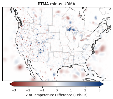
RTMA vs URMA#
For fun, let’s compare the differences between the RTMA and the URMA analyses and see where the differences are for a particular time.
[2]:
# Just open the entire GRIB2 files (opened in multiple DataSets)
rtma = Herbie("2024-06-11 00:00", model="rtma").xarray(verbose=True)
urma = Herbie("2024-06-11 00:00", model="urma").xarray(verbose=True)
✅ Found ┊ model=rtma ┊ product=anl ┊ 2024-Jun-11 00:00 UTC F00 ┊ GRIB2 @ local ┊ IDX @ aws
/home/blaylock/GITHUB/Herbie/herbie/core.py:1097: UserWarning: Will not remove GRIB file because it previously existed.
  warnings.warn("Will not remove GRIB file because it previously existed.")
Note: Returning a list of [5] xarray.Datasets because cfgrib opened with multiple hypercubes.
✅ Found ┊ model=urma ┊ product=anl ┊ 2024-Jun-11 00:00 UTC F00 ┊ GRIB2 @ local ┊ IDX @ aws
/home/blaylock/GITHUB/Herbie/herbie/core.py:1097: UserWarning: Will not remove GRIB file because it previously existed.
  warnings.warn("Will not remove GRIB file because it previously existed.")
Note: Returning a list of [6] xarray.Datasets because cfgrib opened with multiple hypercubes.
[7]:
rtma[3]
[7]:
<xarray.Dataset> Size: 105MB
Dimensions:              (y: 1597, x: 2345)
Coordinates:
    time                 datetime64[ns] 8B 2024-06-11
    step                 timedelta64[ns] 8B 00:00:00
    heightAboveGround    float64 8B 2.0
    latitude             (y, x) float64 30MB 19.23 19.23 19.24 ... 54.38 54.37
    longitude            (y, x) float64 30MB 233.7 233.7 233.8 ... 300.9 301.0
    valid_time           datetime64[ns] 8B 2024-06-11
    gribfile_projection  object 8B None
Dimensions without coordinates: y, x
Data variables:
    t2m                  (y, x) float32 15MB ...
    d2m                  (y, x) float32 15MB ...
    sh2                  (y, x) float32 15MB ...
Attributes:
    GRIB_edition:            2
    GRIB_centre:             kwbc
    GRIB_centreDescription:  US National Weather Service - NCEP
    GRIB_subCentre:          4
    Conventions:             CF-1.7
    institution:             US National Weather Service - NCEP
    model:                   rtma
    product:                 anl
    description:             CONUS Real-Time Mesoscale Analysis (RTMA)
    remote_grib:             /home/blaylock/data/rtma/20240611/rtma2p5.t00z.2...
    local_grib:              /home/blaylock/data/rtma/20240611/rtma2p5.t00z.2...
search: None[8]:
urma[3]
[8]:
<xarray.Dataset> Size: 105MB
Dimensions:              (y: 1597, x: 2345)
Coordinates:
    time                 datetime64[ns] 8B 2024-06-11
    step                 timedelta64[ns] 8B 00:00:00
    heightAboveGround    float64 8B 2.0
    latitude             (y, x) float64 30MB 19.23 19.23 19.24 ... 54.38 54.37
    longitude            (y, x) float64 30MB 233.7 233.7 233.8 ... 300.9 301.0
    valid_time           datetime64[ns] 8B 2024-06-11
    gribfile_projection  object 8B None
Dimensions without coordinates: y, x
Data variables:
    t2m                  (y, x) float32 15MB ...
    d2m                  (y, x) float32 15MB ...
    sh2                  (y, x) float32 15MB ...
Attributes:
    GRIB_edition:            2
    GRIB_centre:             kwbc
    GRIB_centreDescription:  US National Weather Service - NCEP
    GRIB_subCentre:          4
    Conventions:             CF-1.7
    institution:             US National Weather Service - NCEP
    model:                   urma
    product:                 anl
    description:             CONUS Un-Restricted Mesoscale Analysis (URMA)
    remote_grib:             /home/blaylock/data/urma/20240611/urma2p5.t00z.2...
    local_grib:              /home/blaylock/data/urma/20240611/urma2p5.t00z.2...
search: NoneJust to confirm, both the RTMA and URMA have the same grid size and map projection.
[9]:
print("RTMA:", rtma[3].herbie.crs)
print("URMA:", urma[3].herbie.crs)
RTMA: +proj=lcc +ellps=sphere +a=6371200.0 +b=6371200.0 +lon_0=265.0 +lat_0=25.0 +x_0=0.0 +y_0=0.0 +lat_1=25.0 +lat_2=25.0 +no_defs +type=crs
URMA: +proj=lcc +ellps=sphere +a=6371200.0 +b=6371200.0 +lon_0=265.0 +lat_0=25.0 +x_0=0.0 +y_0=0.0 +lat_1=25.0 +lat_2=25.0 +no_defs +type=crs
[3]:
crs = rtma[3].herbie.crs

ax = EasyMap("50m", crs=crs).STATES().ax

art = ax.pcolormesh(
    rtma[3].longitude,
    rtma[3].latitude,
    (rtma[3].t2m - urma[3].t2m),
    transform=pc,
    cmap="herbie.white",  # this is a Custom herbie colormap :)
    vmax=3,
    vmin=-3,
)

ax.set_title("RTMA minus URMA")

art = plt.colorbar(
    art,
    ax=ax,
    label="2 m Temperature Difference (Celsius)",
    orientation="horizontal",
    pad=0.01,
    shrink=0.8,
    extend="both",
)
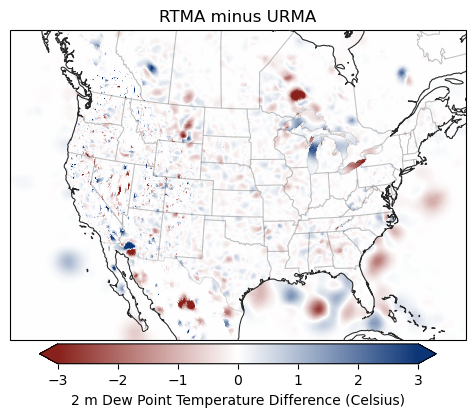
[4]:
crs = rtma[3].herbie.crs

ax = EasyMap("50m", crs=crs).STATES().ax

art = ax.pcolormesh(
    rtma[3].longitude,
    rtma[3].latitude,
    (rtma[3].d2m - urma[3].d2m),
    transform=pc,
    cmap="herbie.white",
    vmax=3,
    vmin=-3,
)

ax.set_title("RTMA minus URMA")

art = plt.colorbar(
    art,
    ax=ax,
    label="2 m Dew Point Temperature Difference (Celsius)",
    orientation="horizontal",
    pad=0.01,
    shrink=0.8,
    extend="both",
)
[5]:
crs = rtma[3].herbie.crs

ax = EasyMap("50m", crs=crs).STATES().ax

art = ax.pcolormesh(
    rtma[2].longitude,
    rtma[2].latitude,
    (rtma[2].si10 - urma[2].si10),
    transform=pc,
    cmap="herbie.white",
    vmax=3,
    vmin=-3,
)

ax.set_title("RTMA minus URMA")

art = plt.colorbar(
    art,
    ax=ax,
    label="10 m Wind Speed Difference (m/s)",
    orientation="horizontal",
    pad=0.01,
    shrink=0.8,
    extend="both",
)
The Kernel crashed while executing code in the current cell or a previous cell.

Please review the code in the cell(s) to identify a possible cause of the failure.

Click <a href='https://aka.ms/vscodeJupyterKernelCrash'>here</a> for more info.

View Jupyter <a href='command:jupyter.viewOutput'>log</a> for further details.
[ ]: