ECMWF Open Data#
This tutorial demonstrates how to use the ECMWF Real-Time Open Data. This data is freely available from ECMWF in GRIB2 format (👀 Read more).
“ The data that are becoming available are based on a range of high-resolution forecasts (HRES – 9 km horizontal resolution) and ensemble forecasts (ENS – 18 km horizontal resolution). They will be made accessible at a resolution of 0.4 x 0.4 degrees”.
Data Sources |prioriy=|Data source| Archive Duration | |–|--|–| |"ecmwf" | ECMWF Open Data | last 4 days |"azure" | Microsoft Azure | 2022-01-21 to present |"aws" | Amazon Web Services| 2023-01-18 to present
Products
|
Product Description |
Available model runs |
|---|---|---|
|
operational high-resolution forecast, atmospheric fields |
|
|
wave forecasts |
|
|
short cut-off high-resolution forecast, atmospheric fields (also known a high-frequency products)”, |
|
|
short cut-off high-resolution forecast, ocean wave fields (also known a high-frequency products)”, |
|
|
ensemble forecast, atmospheric fields |
|
|
ensemble forecast, ocean wave fields, |
|
|
multi-model seasonal forecasts fields from the ECMWF model only. |
? |
Model Initialization
00z, 06z, 12z, 18z. Not all products are available every hour.
[1]:
from herbie import Herbie

import cartopy.crs as ccrs
import matplotlib.pyplot as plt
import numpy as np

from paint.standard2 import cm_tmp, cm_wind, cm_wave_height
from toolbox import EasyMap, pc
[2]:
H = Herbie("2023-02-01", model="ecmwf", product="oper", fxx=12)
✅ Found ┊ model=ecmwf ┊ product=oper ┊ 2023-Feb-01 00:00 UTC F12 ┊ GRIB2 @ azure ┊ IDX @ azure
[4]:
H = Herbie("2023-02-01 06", model="ecmwf", product="oper", fxx=12)
H.grib
✅ Found ┊ model=ecmwf ┊ product=oper ┊ 2023-Feb-01 06:00 UTC F12 ┊ GRIB2 @ azure-scda ┊ IDX @ azure-scda
[4]:
'https://ai4edataeuwest.blob.core.windows.net/ecmwf/20230201/06z/0p4-beta/scda/20230201060000-12h-scda-fc.grib2'
[20]:
H = Herbie("2023-1-23", model="ecmwf", product="oper", fxx=12, priority="azure")
✅ Found ┊ model=ecmwf ┊ product=oper ┊ 2023-Jan-23 00:00 UTC F12 ┊ GRIB2 @ azure ┊ IDX @ azure
[4]:
H.xarray(":2t:")
👨🏻🏭 Created directory: [/home/blaylock/data/ecmwf/20230201]
curl -s --range 16444658-17053704 "https://ai4edataeuwest.blob.core.windows.net/ecmwf/20230201/00z/0p4-beta/oper/20230201000000-12h-oper-fc.grib2" > "/home/blaylock/data/ecmwf/20230201/subset_d712f340__20230201000000-12h-oper-fc.grib2"
[4]:
<xarray.Dataset>
Dimensions:              (latitude: 451, longitude: 900)
Coordinates:
    time                 datetime64[ns] 2023-02-01
    step                 timedelta64[ns] 12:00:00
    heightAboveGround    float64 2.0
  * latitude             (latitude) float64 90.0 89.6 89.2 ... -89.2 -89.6 -90.0
  * longitude            (longitude) float64 -180.0 -179.6 ... 179.2 179.6
    valid_time           datetime64[ns] 2023-02-01T12:00:00
Data variables:
    t2m                  (latitude, longitude) float32 246.4 246.4 ... 240.2
    gribfile_projection  object None
Attributes:
    GRIB_edition:            2
    GRIB_centre:             ecmf
    GRIB_centreDescription:  European Centre for Medium-Range Weather Forecasts
    GRIB_subCentre:          0
    Conventions:             CF-1.7
    institution:             European Centre for Medium-Range Weather Forecasts
    model:                   ecmwf
    product:                 oper
    description:             ECMWF open data
    remote_grib:             https://ai4edataeuwest.blob.core.windows.net/ecm...
    local_grib:              /home/blaylock/data/ecmwf/20230201/subset_d712f3...
searchString: :2t:[ ]:
H = Herbie("2022-01-26", model="ecmwf", product="oper", fxx=12)
Unique Index Files#
The ECMWF index files are different than the wgrib2-style index files, so pay close attention to how you should select the field you want.
[3]:
# Show the searchString_help
print(H.searchString_help)
Use regular expression to search for lines in the index file.
Here are some examples you can use for the ecCodes-style `searchString`

Look at the ECMWF GRIB Parameter Database
https://apps.ecmwf.int/codes/grib/param-db

======================== ==============================================
searchString (oper/enso) Messages that will be downloaded
======================== ==============================================
":2t:"                   2-m temperature
":10u:"                  10-m u wind vector
":10v:"                  10-m v wind vector
":10(u|v):               **10m u and 10m v wind**
":d:"                    Divergence (all levels)
":gh:"                   geopotential height (all levels)
":gh:500"                geopotential height only at 500 hPa
":st:"                   soil temperature
":tp:"                   total precipitation
":msl:"                  mean sea level pressure
":q:"                    Specific Humidity
":r:"                    relative humidity
":ro:"                   Runn-off
":skt:"                  skin temperature
":sp:"                   surface pressure
":t:"                    temperature
":tcwv:"                 Total column vertically integrated water vapor
":vo:"                   Relative vorticity
":v:"                    v wind vector
":u:"                    u wind vector
":(t|u|v|r):"            Temp, u/v wind, RH (all levels)
":500:"                  All variables on the 500 hPa level

======================== ==============================================
searchString (wave/waef) Messages that will be downloaded
======================== ==============================================
":swh:"                  Significant height of wind waves + swell
":mwp:"                  Mean wave period
":mwd:"                  Mean wave direction
":pp1d:"                 Peak wave period
":mp2:"                  Mean zero-crossing wave period

If you need help with regular expression, search the web or look at
this cheatsheet: https://www.petefreitag.com/cheatsheets/regex/.
[4]:
# Pay attention to the "search_this" column
H.inventory()
[4]:
| grib_message | start_byte | end_byte | range | reference_time | valid_time | step | param | levelist | levtype | number | domain | expver | class | type | stream | search_this | |
|---|---|---|---|---|---|---|---|---|---|---|---|---|---|---|---|---|---|
| 0 | 1 | 0 | 609046 | 0-609046 | 2022-01-26 | 2022-01-26 12:00:00 | 0 days 12:00:00 | skt | NaN | sfc | NaN | g | 0001 | od | fc | oper | :skt:sfc:g:0001:od:fc:oper |
| 1 | 2 | 609046 | 1218092 | 609046-1218092 | 2022-01-26 | 2022-01-26 12:00:00 | 0 days 12:00:00 | st | NaN | sfc | NaN | g | 0001 | od | fc | oper | :st:sfc:g:0001:od:fc:oper |
| 2 | 3 | 1218092 | 1827138 | 1218092-1827138 | 2022-01-26 | 2022-01-26 12:00:00 | 0 days 12:00:00 | gh | 1000 | pl | NaN | g | 0001 | od | fc | oper | :gh:1000:pl:g:0001:od:fc:oper |
| 3 | 4 | 1827138 | 2436184 | 1827138-2436184 | 2022-01-26 | 2022-01-26 12:00:00 | 0 days 12:00:00 | gh | 925 | pl | NaN | g | 0001 | od | fc | oper | :gh:925:pl:g:0001:od:fc:oper |
| 4 | 5 | 2436184 | 2842280 | 2436184-2842280 | 2022-01-26 | 2022-01-26 12:00:00 | 0 days 12:00:00 | r | 300 | pl | NaN | g | 0001 | od | fc | oper | :r:300:pl:g:0001:od:fc:oper |
| ... | ... | ... | ... | ... | ... | ... | ... | ... | ... | ... | ... | ... | ... | ... | ... | ... | ... |
| 77 | 78 | 48114266 | 48926262 | 48114266-48926262 | 2022-01-26 | 2022-01-26 12:00:00 | 0 days 12:00:00 | d | 250 | pl | NaN | g | 0001 | od | fc | oper | :d:250:pl:g:0001:od:fc:oper |
| 78 | 79 | 48926262 | 49738258 | 48926262-49738258 | 2022-01-26 | 2022-01-26 12:00:00 | 0 days 12:00:00 | vo | 250 | pl | NaN | g | 0001 | od | fc | oper | :vo:250:pl:g:0001:od:fc:oper |
| 79 | 80 | 49738258 | 50550254 | 49738258-50550254 | 2022-01-26 | 2022-01-26 12:00:00 | 0 days 12:00:00 | vo | 50 | pl | NaN | g | 0001 | od | fc | oper | :vo:50:pl:g:0001:od:fc:oper |
| 80 | 81 | 50550254 | 51159324 | 50550254-51159324 | 2022-01-26 | 2022-01-26 12:00:00 | 0 days 12:00:00 | ro | NaN | sfc | NaN | g | 0001 | od | fc | oper | :ro:sfc:g:0001:od:fc:oper |
| 81 | 82 | 51159324 | 51971320 | 51159324-51971320 | 2022-01-26 | 2022-01-26 12:00:00 | 0 days 12:00:00 | d | 50 | pl | NaN | g | 0001 | od | fc | oper | :d:50:pl:g:0001:od:fc:oper |
82 rows × 17 columns
Ok, now that we have some understanding of the index file, we can read the 2-m temperature data.
[6]:
ds = H.xarray(":2t:")
ds
[6]:
<xarray.Dataset>
Dimensions:              (latitude: 451, longitude: 900)
Coordinates:
    time                 datetime64[ns] 2022-01-26
    step                 timedelta64[ns] 12:00:00
    heightAboveGround    float64 2.0
  * latitude             (latitude) float64 90.0 89.6 89.2 ... -89.2 -89.6 -90.0
  * longitude            (longitude) float64 -180.0 -179.6 ... 179.2 179.6
    valid_time           datetime64[ns] ...
Data variables:
    t2m                  (latitude, longitude) float32 ...
    gribfile_projection  object None
Attributes:
    GRIB_edition:            2
    GRIB_centre:             ecmf
    GRIB_centreDescription:  European Centre for Medium-Range Weather Forecasts
    GRIB_subCentre:          0
    Conventions:             CF-1.7
    institution:             European Centre for Medium-Range Weather Forecasts
    model:                   ecmwf
    product:                 oper
    description:             ECMWF open data
    remote_grib:             C:\Users\blaylock\data\ecmwf\20220126\2022012600...
    local_grib:              C:\Users\blaylock\data\ecmwf\20220126\subset_bf1...
searchString: :2t:[7]:
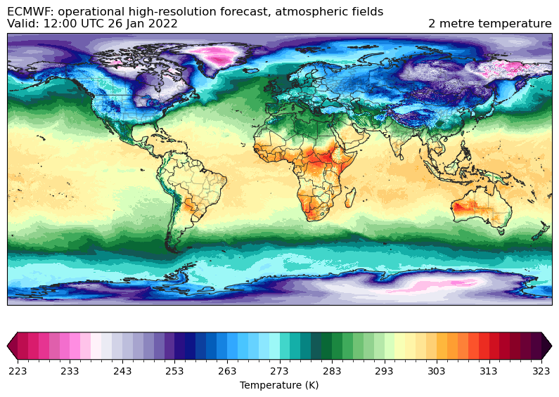
ax = EasyMap("50m", crs=ds.herbie.crs, figsize=[10, 10]).STATES().BORDERS().ax
p = ax.pcolormesh(
    ds.longitude, ds.latitude, ds.t2m, transform=pc, **cm_tmp(units="K").cmap_kwargs
)
plt.colorbar(
    p, ax=ax, orientation="horizontal", pad=0.05, **cm_tmp(units="K").cbar_kwargs
)

ax.set_title(
    f"{ds.model.upper()}: {H.product_description}\nValid: {ds.valid_time.dt.strftime('%H:%M UTC %d %b %Y').item()}",
    loc="left",
)
ax.set_title(ds.t2m.GRIB_name, loc="right")
[7]:
Text(1.0, 1.0, '2 metre temperature')
c:\Users\blaylock\Miniconda3\envs\herbie-dev\lib\site-packages\cartopy\io\__init__.py:241: DownloadWarning: Downloading: https://naturalearth.s3.amazonaws.com/50m_cultural/ne_50m_admin_0_boundary_lines_land.zip
  warnings.warn(f'Downloading: {url}', DownloadWarning)
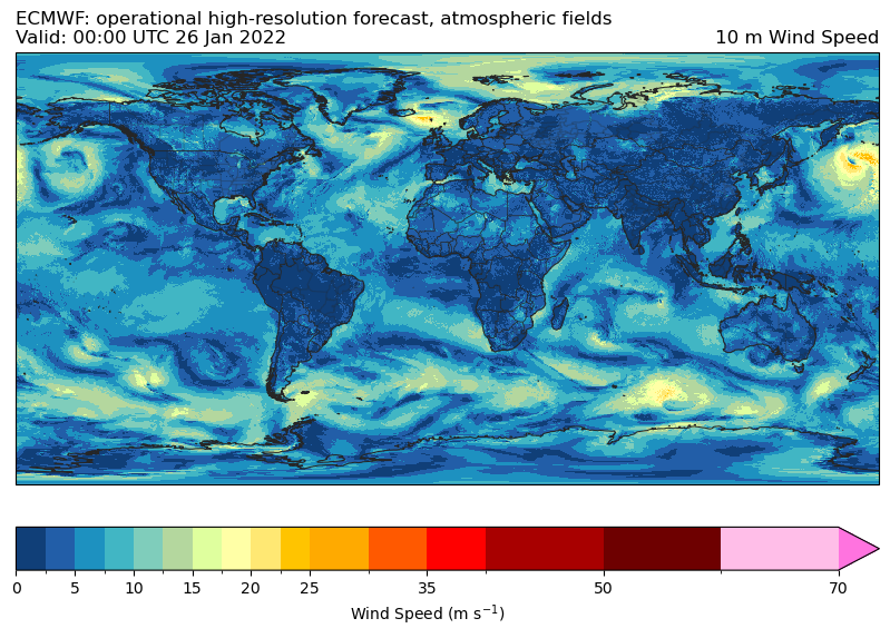
Now the same, but for wind.
[8]:
H = Herbie("2022-01-26", model="ecmwf", product="oper")

# Get u and v wind component
ds = H.xarray(":10(u|v):")

# Compute the wind speed
ds["spd"] = np.sqrt(ds["u10"] ** 2 + ds["v10"] ** 2)

# without too much thought, just quickly copy attributes
ds["spd"].attrs = ds["u10"].attrs.copy()
ds["spd"].attrs["standard_name"] = "wind_speed"
ds["spd"].attrs["long_name"] = "10 m wind speed"
ds["spd"].attrs["GRIB_name"] = "10 m Wind Speed"

ds
✅ Found ┊ model=ecmwf ┊ product=oper ┊ 2022-Jan-26 00:00 UTC F00 ┊ GRIB2 @ azure ┊ IDX @ azure
C:\Users\blaylock\_GITHUB\Herbie\herbie\archive.py:722: UserWarning: This pattern is interpreted as a regular expression, and has match groups. To actually get the groups, use str.extract.
  logic = df.search_this.str.contains(searchString)
C:\Users\blaylock\_GITHUB\Herbie\herbie\archive.py:1041: UserWarning: sorry, on windows I couldn't remove the file.
  warnings.warn("sorry, on windows I couldn't remove the file.")
[8]:
<xarray.Dataset>
Dimensions:              (latitude: 451, longitude: 900)
Coordinates:
    time                 datetime64[ns] 2022-01-26
    step                 timedelta64[ns] 00:00:00
    heightAboveGround    float64 10.0
  * latitude             (latitude) float64 90.0 89.6 89.2 ... -89.2 -89.6 -90.0
  * longitude            (longitude) float64 -180.0 -179.6 ... 179.2 179.6
    valid_time           datetime64[ns] 2022-01-26
Data variables:
    u10                  (latitude, longitude) float32 8.174 8.174 ... -5.998
    v10                  (latitude, longitude) float32 3.499 3.499 ... 3.733
    gribfile_projection  object None
    spd                  (latitude, longitude) float32 8.891 8.891 ... 7.065
Attributes:
    GRIB_edition:            2
    GRIB_centre:             ecmf
    GRIB_centreDescription:  European Centre for Medium-Range Weather Forecasts
    GRIB_subCentre:          0
    Conventions:             CF-1.7
    institution:             European Centre for Medium-Range Weather Forecasts
    model:                   ecmwf
    product:                 oper
    description:             ECMWF open data
    remote_grib:             https://ai4edataeuwest.blob.core.windows.net/ecm...
    local_grib:              C:\Users\blaylock\data\ecmwf\20220126\subset_bfe...
searchString: :10(u|v):[9]:
ax = EasyMap("50m", crs=ds.herbie.crs, figsize=[10, 10]).STATES().BORDERS().ax
p = ax.pcolormesh(
    ds.longitude, ds.latitude, ds.spd, transform=pc, **cm_wind().cmap_kwargs
)
plt.colorbar(p, ax=ax, orientation="horizontal", pad=0.05, **cm_wind().cbar_kwargs)

ax.set_title(
    f"{ds.model.upper()}: {H.product_description}\nValid: {ds.valid_time.dt.strftime('%H:%M UTC %d %b %Y').item()}",
    loc="left",
)
ax.set_title(ds.spd.GRIB_name, loc="right")
[9]:
Text(1.0, 1.0, '10 m Wind Speed')
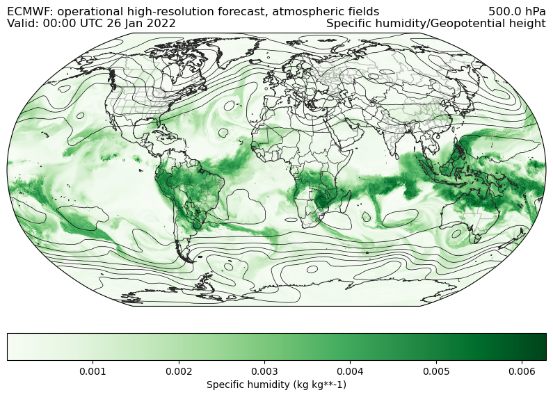
Now lets get the humidity and geopotential height at 500 hPa
[10]:
ds = H.xarray(":(q|gh):500")
ds
C:\Users\blaylock\_GITHUB\Herbie\herbie\archive.py:722: UserWarning: This pattern is interpreted as a regular expression, and has match groups. To actually get the groups, use str.extract.
  logic = df.search_this.str.contains(searchString)
C:\Users\blaylock\_GITHUB\Herbie\herbie\archive.py:1041: UserWarning: sorry, on windows I couldn't remove the file.
  warnings.warn("sorry, on windows I couldn't remove the file.")
[10]:
<xarray.Dataset>
Dimensions:              (latitude: 451, longitude: 900)
Coordinates:
    time                 datetime64[ns] 2022-01-26
    step                 timedelta64[ns] 00:00:00
    isobaricInhPa        float64 500.0
  * latitude             (latitude) float64 90.0 89.6 89.2 ... -89.2 -89.6 -90.0
  * longitude            (longitude) float64 -180.0 -179.6 ... 179.2 179.6
    valid_time           datetime64[ns] 2022-01-26
Data variables:
    q                    (latitude, longitude) float32 6.679e-05 ... 0.0001641
    gh                   (latitude, longitude) float32 5.029e+03 ... 5.136e+03
    gribfile_projection  object None
Attributes:
    GRIB_edition:            2
    GRIB_centre:             ecmf
    GRIB_centreDescription:  European Centre for Medium-Range Weather Forecasts
    GRIB_subCentre:          0
    Conventions:             CF-1.7
    institution:             European Centre for Medium-Range Weather Forecasts
    model:                   ecmwf
    product:                 oper
    description:             ECMWF open data
    remote_grib:             https://ai4edataeuwest.blob.core.windows.net/ecm...
    local_grib:              C:\Users\blaylock\data\ecmwf\20220126\subset_bfe...
searchString: :(q|gh):500[11]:
ax = EasyMap("50m", crs=ccrs.Robinson(), figsize=[10, 10]).STATES().BORDERS().ax

# Color shade by specific humidity
p = ax.pcolormesh(ds.longitude, ds.latitude, ds.q, transform=pc, cmap="Greens")

plt.colorbar(
    p,
    ax=ax,
    orientation="horizontal",
    pad=0.05,
    label=f"{ds.q.GRIB_name} ({ds.q.units})",
)

# Contours for geopotential height
ax.contour(
    ds.longitude,
    ds.latitude,
    ds.gh,
    transform=pc,
    colors="k",
    linewidths=0.5,
    levels=range(0, 10_000, 60 * 2),
)


ax.set_title(
    f"{ds.model.upper()}: {H.product_description}\nValid: {ds.valid_time.dt.strftime('%H:%M UTC %d %b %Y').item()}",
    loc="left",
)
ax.set_title(
    f"{ds.isobaricInhPa.item()} {ds.isobaricInhPa.units}\n{ds.q.GRIB_name}/{ds.gh.GRIB_name}",
    loc="right",
)
[11]:
Text(1.0, 1.0, '500.0 hPa\nSpecific humidity/Geopotential height')
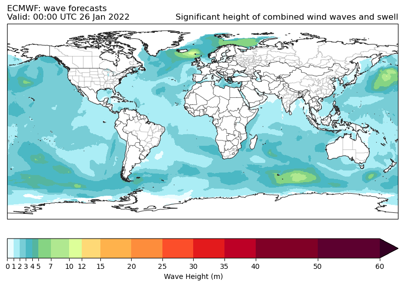
ECMWF Wave Output#
[12]:
H = Herbie("2022-01-26 00:00", model="ecmwf", product="wave")
✅ Found ┊ model=ecmwf ┊ product=wave ┊ 2022-Jan-26 00:00 UTC F00 ┊ GRIB2 @ azure ┊ IDX @ azure
[13]:
ds = H.xarray(None, verbose=True)
ds
✅ Success! Downloaded ECMWF from azure
        src: C:\Users\blaylock\data\ecmwf\20220126\20220126000000-0h-wave-fc.grib2
        dst: C:\Users\blaylock\data\ecmwf\20220126\20220126000000-0h-wave-fc.grib2
C:\Users\blaylock\_GITHUB\Herbie\herbie\archive.py:1041: UserWarning: sorry, on windows I couldn't remove the file.
  warnings.warn("sorry, on windows I couldn't remove the file.")
[13]:
<xarray.Dataset>
Dimensions:              (latitude: 451, longitude: 900)
Coordinates:
    time                 datetime64[ns] 2022-01-26
    step                 timedelta64[ns] 00:00:00
    meanSea              float64 0.0
  * latitude             (latitude) float64 90.0 89.6 89.2 ... -89.2 -89.6 -90.0
  * longitude            (longitude) float64 -180.0 -179.6 ... 179.2 179.6
    valid_time           datetime64[ns] 2022-01-26
Data variables:
    mp2                  (latitude, longitude) float32 nan nan nan ... nan nan
    swh                  (latitude, longitude) float32 nan nan nan ... nan nan
    mwd                  (latitude, longitude) float32 nan nan nan ... nan nan
    pp1d                 (latitude, longitude) float32 nan nan nan ... nan nan
    mwp                  (latitude, longitude) float32 nan nan nan ... nan nan
    gribfile_projection  object None
Attributes:
    GRIB_edition:            2
    GRIB_centre:             ecmf
    GRIB_centreDescription:  European Centre for Medium-Range Weather Forecasts
    GRIB_subCentre:          0
    Conventions:             CF-1.7
    institution:             European Centre for Medium-Range Weather Forecasts
    model:                   ecmwf
    product:                 wave
    description:             ECMWF open data
    remote_grib:             C:\Users\blaylock\data\ecmwf\20220126\2022012600...
    local_grib:              C:\Users\blaylock\data\ecmwf\20220126\2022012600...
searchString: None[14]:
ax = EasyMap("50m", crs=ds.herbie.crs, figsize=[10, 10]).STATES().BORDERS().ax
p = ax.pcolormesh(
    ds.longitude,
    ds.latitude,
    ds.swh,
    transform=pc,
    **cm_wave_height(units="m").cmap_kwargs,
)
plt.colorbar(
    p,
    ax=ax,
    orientation="horizontal",
    pad=0.05,
    **cm_wave_height(units="m").cbar_kwargs,
)

ax.set_title(
    f"{ds.model.upper()}: {H.product_description}\nValid: {ds.valid_time.dt.strftime('%H:%M UTC %d %b %Y').item()}",
    loc="left",
)
ax.set_title(ds.swh.GRIB_name, loc="right")
[14]:
Text(1.0, 1.0, 'Significant height of combined wind waves and swell')
Ensemble Forecast Products#
[ ]:
H = Herbie("2022-01-26 00:00", model="ecmwf", product="enfo")
ds = H.xarray(":2t:")
ds
[ ]:
# Dataset with all 50 members
ds[0]
[ ]:
# This Dataset is of the mean of all the members, right?
ds[1]
[ ]:
H.idx
Ensemble Wave Products#
[ ]:
H = Herbie("2022-01-26 00:00", model="ecmwf", product="waef")
ds = H.xarray(None)
ds
[ ]:
len(ds)
[ ]:
ds[0]
[ ]:
ds[1]
[ ]:
H = Herbie("2022-01-26", model="ecmwf", product="enfo")
H.inventory()
[ ]:
Here is another examle, just for fun
[ ]:
H = Herbie("2022-01-26", model="ecmwf", product="oper", fxx=12)
[ ]:
# Download the full grib2 file
H.download()
[ ]:
# Download just the 10-m u and v winds
H.download(searchString=":10(u|v):")
[ ]:
# Retrieve the 500 hPa temperature as an xarray.Dataset
ds = H.xarray(searchString=":t:500:")
[ ]:
ds
[ ]:
ds.t.plot()
Copyright statement: Copyright “© 2022 European Centre for Medium-Range Weather Forecasts (ECMWF)”.
Source www.ecmwf.int
Licence Statement: This data is published under a Creative Commons Attribution 4.0 International (CC BY 4.0). https://creativecommons.org/licenses/by/4.0/
Disclaimer: ECMWF does not accept any liability whatsoever for any error or omission in the data, their availability, or for any loss or damage arising from their use.